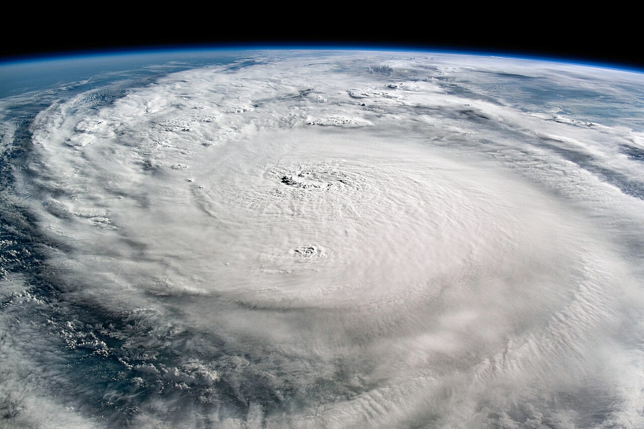
The thin blue curve at the top of the photograph belongs to Earth. Beneath it, an enormous textured cloud system spreads across the frame. This is Hurricane Milton, photographed from the International Space Station on October 8, 2024, by a member of the Expedition 72 crew. It is a retrospective image, not a storm approaching today. 1
The first surprise is the change of viewpoint. A weather map turns a hurricane into a symbol or a coloured spiral. Here the camera shows cloud texture beneath a dark sky and a visible horizon. The scene has the unsettling beauty of a landscape that is also a moving weather system.
A real camera above a real storm
NASA identifies the astronaut photograph as ISS072-E-29325, taken with a Nikon Z 9 and a 50-millimetre lens. Its published version was cropped and adjusted for contrast, with lens artifacts removed. Those production details are part of the image's record; this is an actual photograph with documented processing, rather than an invented view of a hurricane. 1
The supplied picture gives a broad, slanting view across the clouds. The broad view places the cloud system beneath the horizon, making the relationship between storm and planet particularly striking. Different cloud textures are visible across the frame. The change from textured foreground to distant blue rim gives the picture depth that a flat map of the same system would present differently.
Follow the foreground texture toward the horizon. Small-looking puffs and larger sweeps of cloud occupy the same image, making scale difficult to judge without the orbital context. The blue rim supplies the strongest visual cue: the scene is being seen from above the atmosphere's familiar ground-level perspective.
What happened after the photograph
Milton crossed the Gulf of Mexico before reaching Florida. The National Weather Service records landfall near Siesta Key on the evening of October 9, 2024, as a Category 3 hurricane. That happened after this photograph was taken. Keeping the dates separate prevents a striking image from becoming a misleading picture of the exact landfall moment. 2
NOAA's season review also records a tornado outbreak and heavy rainfall associated with Milton. The event was a destructive hurricane, not simply an unusual cloud pattern that happened to photograph well. The orbital view makes the overall system visible while leaving much of the experience on the ground outside the frame. 3
An eye is only one part of a hurricane
NOAA's explanation of cyclone structure distinguishes the central eye, the surrounding eyewall and the outer rainbands. Air generally sinks in the eye, while the eyewall contains powerful rising air and intense weather. A relatively calm centre can exist within a dangerous storm. 4
That explanation helps with a common visual habit: looking only for the eye. The wider cloud system also matters, and the hazard does not end at the edge of a neat circle on a screen. NOAA specifically warns that an eye's temporary lull can be mistaken for the end of a hurricane.
This photograph invites a different second look. Instead of searching for a tiny point to label, notice how much of the view belongs to the system around it. The image's reach is the remarkable detail. One October 2024 camera frame holds a storm beneath the curve of the planet—and still cannot show everything the storm was doing.